PHYSICAL GEOGRAPHY AND ENVIRONMENTAL GEOSCIENCE
Type of resources
Keywords
Publication year
Topics
-
Managed aquifer recharge (MAR) enhances recharge to aquifers. As part of the Exploring for the Future Southern Stuart Corridor project, remotely sensed data were used to map regolith materials and landforms, and to identify areas that represent potential MAR target areas for future investigation. Nine areas were identified, predominantly associated with alluvial landforms in low-gradient landscape settings. The surface materials are typically sandy, or sandy and silty, with the prospective areas overlying newly identified groundwater resources associated with Paleozoic sedimentary rocks of the Wiso and Georgina basins. The workflow used here can be rapidly rolled out across broader areas, and can be supplemented by higher-resolution, longer time-series remote-sensing data, coupled with data analytics, modelling and expert knowledge. Such an approach will help to identify areas of the arid interior that may be suitable for MAR schemes that could supplement water for remote communities, and agricultural and other natural resource developments. <b>Citation:</b> Smith, M.L., Hostetler, S. and Northey, J., 2020. Managed aquifer recharge prospectivity mapping in the Northern Territory arid zone using remotely sensed data. In: Czarnota, K., Roach, I., Abbott, S., Haynes, M., Kositcin, N., Ray, A. and Slatter, E. (eds.) Exploring for the Future: Extended Abstracts, Geoscience Australia, Canberra, 1–4.
-
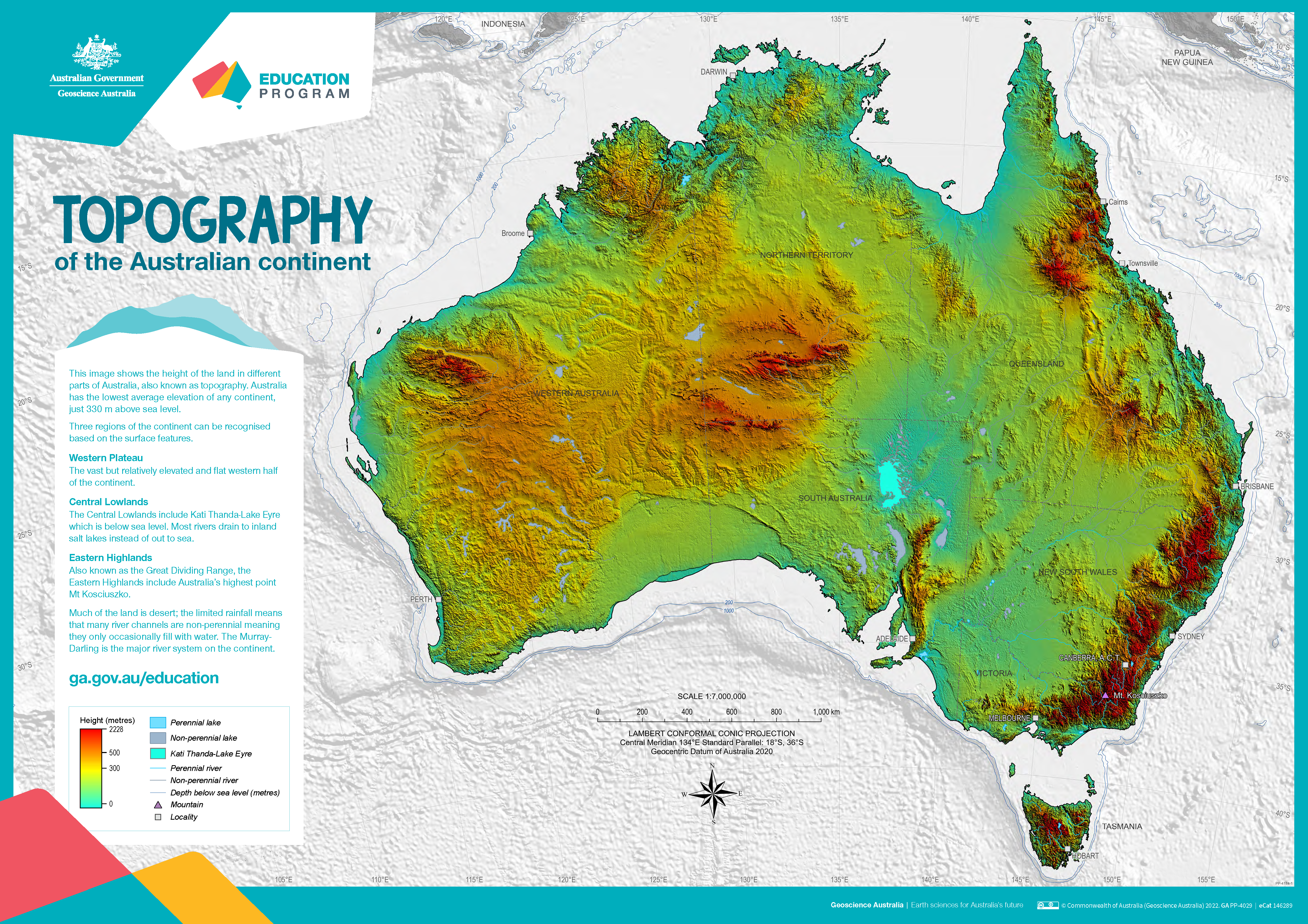
The poster uses a colourful digital elevation model to show the topography of the Australian continent. Low land is shown in green, higher land is yellow and orange and the highest parts of the country appear red. The map also shows perennial and non-perennial lakes and rivers as well as the location of the highest point in Australia and Kati Thanda-Lake Eyre at below sea level. The surrounding 200 m and 1000 m seabed depths contours are shown against a grey background. An accompanying text box outlines the three main physical regions of the county: the western plateau, central lowlands and eastern highlands. The poster is designed to be printed at A1 size which is 1:7 000 000 scale.
-
The gnssanalysis Python package is designed to provide the public with a source of useful python functions and classes that help with processing of GNSS observations. The functionality found within the package includes: - reading of many standard file formats commonly used in the geodetic community including SP3, SNX, RNX, CLK, PSD, etc. into pandas dataframes (Also writing certain file formats) - transformation of data, for example datetime conversions, helmert inversions, rotations, transforming geodata from XYZ to longitude-latitude-altitude, etc. - functions for the download of standard files and upload to other sources (e.g. s3)
-
This Gunnedah Basin dataset contains descriptive attribute information for the areas bounded by the relevant spatial groundwater feature in the associated Hydrogeology Index map. Descriptive topics are grouped into the following themes: Location and administration; Demographics; Physical geography; Surface water; Geology; Hydrogeology; Groundwater; Groundwater management and use; Environment; Land use and industry types; and Scientific stimulus. The Gunnedah Basin is an intracratonic, sedimentary basin in northern NSW. It forms the middle section of the greater Sydney-Gunnedah-Bowen Basin system and mainly consists of Permian and Triassic sedimentary rocks resting on Late Carboniferous to Early Permian volcanics. The Gunnedah Basin is overlain by the Surat Basin and the younger alluvial sediments associated with modern and ancient river systems. The Gunnedah Basin is not considered a single well-connected aquifer, rather a series of porous rock aquifers separated by several non-porous or poorly conductive layers. The Lachlan Fold Belt forms what is thought to be an effective basement although little information is known of its hydrogeological properties. All units of the Gunnedah Basin are of low permeability and significantly lower hydraulic conductivity than the overlying alluvial aquifers. Most of the groundwater resources in the area are extracted from either the overlying Surat Basin or younger alluvial aquifers. There is relatively little groundwater sourced from the aquifers of the Gunnedah Basin, except in areas where the overlying aquifers do not occur. The most viable groundwater source in the Gunnedah Basin are the more porous aquifers of the Triassic sequence.
-
This Wiso Basin dataset contains descriptive attribute information for the areas bounded by the relevant spatial groundwater feature in the associated Hydrogeology Index map. Descriptive topics are grouped into the following themes: Location and administration; Demographics; Physical geography; Surface water; Geology; Hydrogeology; Groundwater; Groundwater management and use; Environment; Land use and industry types; and Scientific stimulus. The Wiso Basin, a large intra-cratonic basin in the central Northern Territory, covers about 140,000 square kilometres and is part of the Centralian Superbasin. It is bounded by the Tennant and Tanami regions to the east and west, while a thrust fault separates it from the Arunta Region to the south. The basin adjoins the Georgina Basin in the southeast and joins the Daly and Georgina basins beneath the Cretaceous strata of the Carpentaria Basin in the north. The basin contains a relatively flat, undeformed succession of strata that gently dip towards the main depo-centre, the Lander Trough. About 80% of the basin consists of shallow middle Cambrian strata, while the remaining portion is within the Lander Trough, containing a diverse succession of Cambrian, Ordovician, and Devonian units. The depositional history and stratigraphy reveal that early Cambrian saw widespread basaltic volcanism, with the Antrim Plateau Volcanics forming the base layer and aquitard of the Wiso Basin. The middle Cambrian deposits include the Montejinni Limestone, the oldest sedimentary unit, followed by the Hooker Creek Formation and the Lothari Hills Sandstone. The uppermost Cambrian unit is the Point Wakefield beds. The Ordovician deposits consist of the Hansen River beds, primarily composed of fossiliferous sandstone and siltstone deposited in shallow marine environments. The Devonian unit capping the basin is the Lake Surprise Sandstone, found in the Lander Trough area, formed in shallow marine, shoreline, and fluvial environments during the Alice Springs Orogeny. Three main hypotheses have been proposed for the formation of the Lander Trough: a large crustal downwarp before thrusting of Paleoproterozoic rocks, the formation of a half-graben by faulting along the southern boundary, or the formation of two en-echelon synclines by vertical block movement. While the majority of the Wiso Basin consists of shallow middle Cambrian rocks, the Lander Trough presents a more varied stratigraphic sequence, holding potential for Neoproterozoic and early Cambrian rocks. However, further drilling is needed to verify this. The presence of similar units in neighbouring basins provides valuable insight into the basin's geological history and development.
-
This Perth Basin dataset contains descriptive attribute information for the areas bounded by the relevant spatial groundwater feature in the associated Hydrogeology Index map. Descriptive topics are grouped into the following themes: Location and administration; Demographics; Physical geography; Surface water; Geology; Hydrogeology; Groundwater; Groundwater management and use; Environment; Land use and industry types; and Scientific stimulus. The Perth Basin is a complex geological region extending along Australia's southwest margin for about 1,300 km. It comprises sub-basins, troughs, terraces, and shelves, hosting sedimentary rocks with coal, oil, gas, and significant groundwater resources. Off the coast of Western Australia, it reaches depths of up to 4,500 m, while its onshore part extends up to 90 km inland. The basin is bounded by the Yilgarn Craton to the east, and the Carnarvon and Bremer basins to the north and south. The basin's history involves two main rifting phases in the Permian and Late Jurassic to Early Cretaceous, creating 15 sub-basins with varying sedimentary thickness due to compartmentalization and fault reactivation. The sedimentary succession mainly comprises fluviatile Permian to Early Cretaceous rocks over Archean and Proterozoic basement blocks. Differences exist between northern and southern sequences, with the south being continental and the north featuring marine deposits. During the Permian, faulting and clastic sedimentation dominated, with marine transgressions in the north and continental rocks in the south. The Triassic saw a similar pattern, with the southern succession being continental and the northern succession showing marine deposits. The Kockatea Shale became a primary hydrocarbon source. The Jurassic period witnessed marine incursions in the central basin, while the Late Jurassic experienced sea level regression and deposition of the Yarragadee Formation. The Cretaceous saw the formation of the Early Cretaceous Parmelia Group due to heavy tectonic activity. The southern basin had a marine transgression leading to the Warnbro Group's deposition with valuable groundwater resources. Post-Cretaceous, Cenozoic deposits covered the basin with varying thicknesses. Overall, the Perth Basin's geological history reveals a diverse sedimentary record with economic and resource significance.
-
This Carnarvon Basin dataset contains descriptive attribute information for the areas bounded by the relevant spatial groundwater feature in the associated Hydrogeology Index map. Descriptive topics are grouped into the following themes: Location and administration; Demographics; Physical geography; Surface water; Geology; Hydrogeology; Groundwater; Groundwater management and use; Environment; Land use and industry types; and Scientific stimulus. The Carnarvon Basin is a large sedimentary basin covering the western and north-western coast of Western Australia, stretching over 1,000 km from Geraldton to Karratha. It is predominantly offshore, with over 80% of the basin located in water depths of up to 4,500 m. The basin is elongated north to south and connects to the Perth Basin in the south and the offshore Canning Basin in the north-east. It is underlain by Precambrian crystalline basement rocks. The Carnarvon Basin consists of two distinct parts. The southern portion comprises onshore sub-basins with mainly Paleozoic sedimentary rocks extending up to 300 km inland, while the northern section consists of offshore sub-basins containing Mesozoic, Cenozoic, and Paleozoic sequences. The geological evolution of the Southern Carnarvon Basin was shaped by multiple extensional episodes related to the breakup of Gondwana and reactivation of Archean and Proterozoic structures. The collision between Australia and Eurasia in the Mid-Miocene caused significant fault reactivation and inversion. The onshore region experienced arid conditions, leading to the formation of calcrete, followed by alluvial and eolian deposition and continued calcareous deposition offshore. The Northern Carnarvon Basin contains up to 15,000 m of sedimentary infill, primarily composed of siliciclastic deltaic to marine sediments from the Triassic to Early Cretaceous and shelf carbonates from the Mid-Cretaceous to Cenozoic. The basin is a significant hydrocarbon province, with most of the resources found within Upper Triassic, Jurassic, and Lower Cretaceous sandstone reservoirs. The basin's development occurred during four successive periods of extension and thermal subsidence, resulting in the formation of various sub-basins and structural highs. Overall, the Carnarvon Basin is a geologically complex region with a rich sedimentary history and significant hydrocarbon resources. Exploration drilling has been ongoing since 1953, with numerous wells drilled to unlock its hydrocarbon potential.
-
This Maryborough-Nambour Basin dataset contains descriptive attribute information for the areas bounded by the relevant spatial groundwater feature in the associated Hydrogeology Index map. Descriptive topics are grouped into the following themes: Location and administration; Demographics; Physical geography; Surface water; Geology; Hydrogeology; Groundwater; Groundwater management and use; Environment; Land use and industry types; and Scientific stimulus. The Maryborough Basin is a half-graben intracratonic sag basin mainly filled with Early Cretaceous rocks, overlain by up to 100 m of Cenozoic sediments. It adjoins the older Nambour Basin to the south, comprising Triassic to Jurassic rocks. The boundary between the basins has shifted due to changes in sedimentary unit classifications, with the Cretaceous units now restricted to the Maryborough Basin and Jurassic and older units assigned to the Nambour Basin. Both basins are bounded to the west and unconformably overlies older Permian and Triassic rocks in the Gympie Province and Wandilla Province of the New England Orogen. In the south of the Nambour Basin, it partly overlaps with the Triassic Ipswich Basin. The Nambour Basin in the south is primarily composed of the Nambour Formation, with interbedded conglomerate, sandstone, siltstone, shale, and minor coal. Overlying this is the Landsborough Sandstone, a unit with continental, fluviatile sediments and a thickness of up to 450 m. In the north, the Duckinwilla Group contains the Myrtle Creek Sandstone and the Tiaro Coal Measures, which were formerly considered part of the Maryborough Basin but are now associated with the northern Nambour Basin. In contrast, the Maryborough Basin consists of three main Cretaceous units and an upper Cenozoic unit. The Grahams Creek Formation is the deepest, featuring terrestrial volcanic rocks, volcaniclastic sedimentary rocks, and minor pyroclastic rocks. The overlying Maryborough Formation was deposited in a continental environment with subsequent marine incursion and includes mudstone, siltstone, minor sandstone, limestone, conglomerate, and tuff. The upper Cretaceous unit is the Burrum Coal Measures, comprising interbedded sedimentary rocks deposited in fluvial to deltaic environments. The uppermost unit, the Eocene to Miocene Elliott Formation, includes sandstone, siltstone, conglomerate, and shale deposited in fluvial to deltaic environments. Cenozoic sediments overlying the Elliott Formation consist of Quaternary alluvium, coastal deposits, and sand islands like Fraser Island, influenced by eustatic sea level variations. Volcanic deposits and freshwater sediments also occur in some areas. Adjacent basins, such as the Clarence-Moreton Basin and Capricorn Basin, have stratigraphic correlations with the Maryborough Basin. The Oxley Basin lies to the south, overlying the Ipswich Basin. In summary, the Maryborough Basin and the older Nambour Basin exhibit distinct geological characteristics, with varying rock formations, ages, and sedimentary features, contributing to the diverse landscape of the region.
-
This Surat Basin dataset contains descriptive attribute information for the areas bounded by the relevant spatial groundwater feature in the associated Hydrogeology Index map. Descriptive topics are grouped into the following themes: Location and administration; Demographics; Physical geography; Surface water; Geology; Hydrogeology; Groundwater; Groundwater management and use; Environment; Land use and industry types; and Scientific stimulus. The Surat Basin is a sedimentary basin with approximately 2500 m of clastic fluvial, estuarine, coastal plain, and shallow marine sedimentary rocks, including sandstone, siltstone, mudstone, and coal. Deposition occurred over six cycles from the Early Jurassic to the Cretaceous, influenced by eustatic sea-level changes. Each cycle lasted 10 to 20 million years, ending around the mid-Cretaceous. Bounded by the Auburn Arch to the northeast and the New England Orogen to the southeast, it connects to the Clarence-Moreton Basin through the Kumbarilla Ridge. The Central Fold Belt forms its southern edge, while Cenozoic uplift caused erosion in the north. The basin's architecture is influenced by pre-existing faults and folds in the underlying Bowen Basin and the nature of the basement rocks from underlying orogenic complexes. Notable features include the north-trending Mimosa Syncline and Boomi Trough, overlying the deeper Taroom Trough of the Bowen Basin and extending southwards. The Surat Basin overlies older Permian to Triassic sedimentary basins like the Bowen and Gunnedah Basins, unconformably resting on various older basement rock terranes, such as the Lachlan Orogen, New England Orogen, and Thomson Orogen. Several Palaeozoic basement highs mark its boundaries, including the Eulo-Nebine Ridge in the west and the Kumbarilla Ridge in the east. Paleogene to Neogene sediments, like those from the Glendower Formation, cover parts of the Surat Basin. Remnant pediments and Cenozoic palaeovalleys incised into the basin have added complexity to its geological history and may influence aquifer connections. Overall, the Surat Basin's geological history is characterized by millions of years of sedimentation, tectonic activity, and erosion, contributing to its geological diversity and economic significance as a source of natural resources, including coal and natural gas.
-
This Carpentaria Basin dataset contains descriptive attribute information for the areas bounded by the relevant spatial groundwater feature in the associated Hydrogeology Index map. Descriptive topics are grouped into the following themes: Location and administration; Demographics; Physical geography; Surface water; Geology; Hydrogeology; Groundwater; Groundwater management and use; Environment; Land use and industry types; and Scientific stimulus. The Carpentaria Basin is a vast intra-cratonic sedimentary basin situated on and offshore in north-eastern Australia, covering around 550,000 square kilometres across Queensland and the Northern Territory. It comprises predominantly sandstone-rich rock units deposited during sea level highs from the Late Jurassic to Mid Cretaceous. The basin overlies a heterogeneous Proterozoic basement and is separated from contemporaneous sedimentary structures by basement highs and inliers. Four main depocentres within the larger Carpentaria Basin form four major sub-basins: the Western Gulf Sub-basin, Staaten Sub-basin, Weipa Sub-basin, and Boomara Sub-basin. While the basin is extensive and continuous in Queensland, it becomes more heterogeneous and discontinuous in the Northern Territory. Remnants of the basin's stratigraphy, referred to as the Dunmarra Basin, are found along the Northern Territory coast and inland. The depositional history commenced during the Jurassic with down warping near Cape York Peninsula, resulting in the Helby beds and Albany Pass beds' concurrent deposition. The basin experienced marine transgressions during the Cretaceous, with the Gilbert River Formation widespread and the Wallumbilla Formation occurring during sea level highs. The Carpentaria Basin's strata are relatively undeformed and unmetamorphosed. The Northern Territory sequence displays slightly different stratigraphy, limited to the height of the Aptian marine transgression above the Georgina Basin. The Walker River Formation and Yirrkala Formation represent key units in this area, outcropping as tablelands and mesas largely unaffected by tectonism.